The First Air Traffic Controller
 |
| Archie William League is shown on duty in his summer office. Note the rolled-up flags in the wheelbarrow, and the dangling lunch box. His other equipment included a folding chair, drinking water, and a pad for taking notes. |
League had been a licensed pilot, and licensed engine and aircraft mechanic. He had barnstormed around in Missouri and Illinois with his "flying circus," prior to St. Louis hiring him as the first U.S. air traffic controller in 1929. He was stationed at the airfield in St. Louis, Missouri (now known as Lambert-St. Louis International Airport). Before the installation of a radio tower, he was a flagman who directed traffic via flags. His first "control tower" consisted of a wheelbarrow on which he mounted a beach umbrella for the summer heat. In it he carried a beach chair, his lunch, water, a note pad and a pair of signal flags to direct the aircraft. He used a checkered flag to indicate to the pilot "GO", i.e. proceed, or a red flag to indicate the pilot should "HOLD" their position. He kept warm out on the field in the winters by wearing a padded flying suit. When a radio tower was installed in the early 1930s, he became the airport's first radio controller.
League went on to earn a degree in aeronautical engineering from Washington University in St. Louis. League joined the Federal service in 1937 at the Bureau of Air Commerce (the precursor to the Civil Aeronautics Authority, and the Federal Aviation Administration). He rose rapidly through the ranks as an Air Traffic controller, served as a pilot in World War II (where he rose to the rank of Colonel) then progressed to his first top management position in 1956, as Assistant Regional Administrator of the Central Region. He next went to Washington headquarters as Chief of the Planning Division (Planning and Development Office) in 1958. After a short assignment as Director, Bureau of National Capital Airports, he moved to Fort Worth as the Director of Southwest Region. His next assignment was in May 1965, relocating to Washington headquarters as Director of Air Traffic Services, where he became head of the staff responsible for the safe and efficient operation of the nation’s air traffic control system. He eventually became FAA's Air Traffic Service director and retired as an Assistant Administrator for Appraisal in 1973. During his 36-year career he helped develop the federal air traffic control system. The National Air Traffic Controllers Association (NATCA) named the Archie League Medal of Safety Awards after him.
He was born in 1907 at Poplar Bluff, Missouri in Butler County. He died on October 1, 1986 at the age of 79 in Annandale, Virginia.
Republished from Wikipedia, Archie William League, Creative Commons License.
Cypress Memories
By Jason Wilson
The area had once been forest and field, meadowland and swamp. A healthy stream ran through the area, fed by many springs at its headwaters and from several tributaries along its length, as it coursed through the region of Northwest St. Louis County. These springs also gave the stream its name; Coldwater. This was highland area, not far from the river named Missouri. It had long been settled, first by the native tribes, and then the French, who gave it the name, Marais des Liards. They were soon followed by the Spanish and then the Americans. It was also crossed by an old Indian trail along the high ground. This trail became a road, and was used by the settlers traveling overland from the settlements of St. Louis and St. Charles. This trail was soon paved with crushed stone, the first of its kind in St. Louis County. It became known as the, “St. Charles Rock Road.”
.JPG) |
| Emmet and Wanza Wilson, circa 1947. |
Time passed, farms arose, and the fertile soil was heavily worked. The population grew, and in time, the late 1940s arrived. After WWII, there were many families seeking the new life in “suburbia.” This was virgin land and several developers had ideas. One in particular, Charles F. Vatterott, Jr., dreamed of a planned community with homes, stores, churches, and schools. This was when my family arrived, or more correctly, my parents and my two older siblings.
Like many people, my dad was eager to build a new home far from the city. In fact, he told me that many of his friends chided him for wanting to build, “so damned far out in the country.” He had whittled his choices down to two plots. The first was along a narrow country lane named Clayton Road (near another dusty path called Spoede Road, about a quarter mile south of the “new” Highway 40 and one quarter mile west of Lindbergh Boulevard).
The second piece of property that he had in mind was along another farm road called Cypress. Cypress Road ran north from St. Charles Rock Road, east of Lindbergh Boulevard (which had been recently upgraded with a series of what were then, state-of-the-art cloverleaf intersections). Cypress also intersected with Natural Bridge Road, just west of Lambert Field and east of the small community of Bridgeton, Missouri. This was the parcel that my parents finally chose.
A beautiful home was built, among the first homes along this road, with one of them being an old, surviving farmhouse. This home, designed by my father, was built in the late 40s contemporary style and would be modest by today’s standards. The house was built of block and brick, with wooden floors, a hip roof, a full basement, and there was a large breezeway connecting the house to an oversize two-car garage.
Other homes, also privately built and on large lots, all joined one another along Cypress in short order. A cul-de-sac was platted out with more such homes on generous lots. This street was given the heady name of Cypress Gardens Court. More such development was planned, and Cypress was only the beginning. There would be future development to the east of Cypress, all the way to Coldwater Creek.
 |
| From the book, St. Ann, Missouri - Thirty-Five Years, by Sue Smith |
I remember my friends and I playing all day, from sun-up to sun-down, running through yards, playing in Coldwater Creek, crawdad hunting, and riding bikes.
There was such a variety of foods on the trees that no one went hungry. We had peaches, apples, cherries, grapes, and pears. The family of a good friend of mine owned a huge Quarter Horse named Guy, and he could carry several of us throughout the neighborhood.
In the late 1950s, a small food shop (a forerunner of the convenience stores now found on every corner) opened up on Cypress, about a half-mile south of my home, where a branch of Coldwater Creek crossed under Cypress. This was a great source of treats and inexpensive toys for the neighborhood children. We bought many balsa wood planes and other trinkets there.
Mine was a bucolic, almost nineteenth-century childhood, given the activities in which we participated, yet it was set firmly in the mid-twentieth century. We had walk-in and drive-in movie theatres, grocery stores, dime stores, a store dedicated to televisions, and one specifically for shoes. St. Ann had become a suburb in its own right by the 1950s, and was self-governing, with its own police force. My parents knew the police chief and many of the local officers. St. Ann was a “people community.” You knew your neighbors, you knew the grocer, and you knew the cop on the beat. It was more than just a suburb of St. Louis; it was a unique small town.
My family moved from our home on Cypress in November 1963. Traffic on Cypress Road was growing beyond its capabilities. We moved to the newest of the planned communities: Carrollton, just a few miles west in the neighboring suburb of Bridgeton, Missouri. Carrollton also had good schools, churches, and a large shopping center, but the homes were decidedly of a mid-century Modern style. Tract homes, certainly, but more modern than any that had existed in the area before.
Thus, when I was 12 years old, my life in Northwest County entered a second act. My early childhood was spent on Cypress Road in St. Ann, a childhood I hold dear and remember fondly. My adolescence was spent in Bridgeton, and many adventures began there as well. I’m proud to have so many happy memories of these great communities, just two of the many that exist in Northwest St. Louis County.
Streetcars Changed the Course of

Thanks to the M-G-M film musical “Meet Me in St. Louis
In fact it was one of the most comprehensive in the nation, and notable because so much of the streetcar lines traveled not on streets but through woodlands and rural areas to far distant spots. Including the city of St. Charles Missouri River !
The streetcar line in the film really did exist; it was the Hodiamont line and it passed the west of the Wellston Loop at
That was where the St. Charles Rock Road Mississippi Missouri Rock Road St. Charles
Few histories accurately record the route of the line and few record the fact that the present location of theRock Road
Few histories accurately record the route of the line and few record the fact that the present location of the
The line was built by the enterprising James Houseman beginning in 1897 in stages westward, originally terminating on the east side of the Missouri River, where passengers rode ferry boats across to St. Charles. Then in 1904 a bridge was built over the river and the trolley line terminal still stands just off where its exit landed in
The line was double-tracked in the middle of the road west from Wellston. Just east of Lucas and Hunt Road St. Peters Natural Bridge
West of Lucas and Hunt each track spread to the south and north sides of the Rock Road St. Vincent ’s Lane in Pagedale, where they spread to the outside lanes.
In the early days the line met the Cross Country line which came north up
At Brown Road (which was Birdie Avenue), where the car barn was located (the bus barn north of it still stands, hidden behind Walgreen’s Drugs), the line narrowed to one rail, and at what is now Cypress Road, the Bridgeton Line branched off to head north for what is now Lambert Field.
Most histories have the line following the Rock Road St. Charles Bridgeton Rock Road Natural Bridge Rock Road Westlake Amusement park Westlake Park
The streetcar line west of Westlake Park Woodson Road Airline Avenue Woodson Road Woodson Road Edmundson Road
When the streetcar stopped running west of Woodson, the state was able to recreate
In fact, before that, several portions of the Rock Road St. John St. Ann Adie Road Old St. Charles Road
Amazingly, parts of the streetcar right-of-way remain, most notably at Fee Fee, where “Electric Avenue” at one time stood just north of the Rock Road and a short patch of right-of-way and electrical sustation still stands on the west side of the road. The right-of-way is also visible north on McKelvey Road , where it follows a creek and winds through a townhouse development, poles still in place and, most amazingly, a short stretch of the embankment is visible on the south side of the Rock Road just east of Earth City Expressway.
James Houseman was very proud of his electric line, nicknamed the “All Saints” because it served so many cemeteries. His luxurious cars included toilet facilities and phones, kept to schedules, stopped wherever passengers awaited (at night lighting newspapers to signal the motorman to halt) and were equipped with loud air horns and gigantic headlights to pierce the dark countryside.
What a saga! And now almost all forgotten or, if remembered, gotten wrong. Not now.
A Tardy Pardon and Other Buried Treasures
By Kyle Schrader
As he picks up flowers spilled by April showers, Kenneth “Ken” Cox points to a grave etched as being shared by Benjamin, George, and Dennis Lackland and explains, “When there was a flu epidemic, it was not unusual to have two children buried together, or a mother and child.”
Cox, chairman of trustees of the Fee Fee Cemetery Association, is perusing the grounds, located on Old Saint Charles Road Bridgeton Washington Monument
A man with appreciation for the details and history of Fee Fee Cemetery
Cox verifies the historical significance, stating, “It is the first and oldest active cemetery west of the
Besides the Lackland family name, one scanning headstones might also see the locally recognizable Adie, Hickman, Hanley, Averill, and Branneky surnames, just to name a few. Regarding family plots, Cox asserts, “People bought lots back on the 1930s and are just now using the rest of them.”
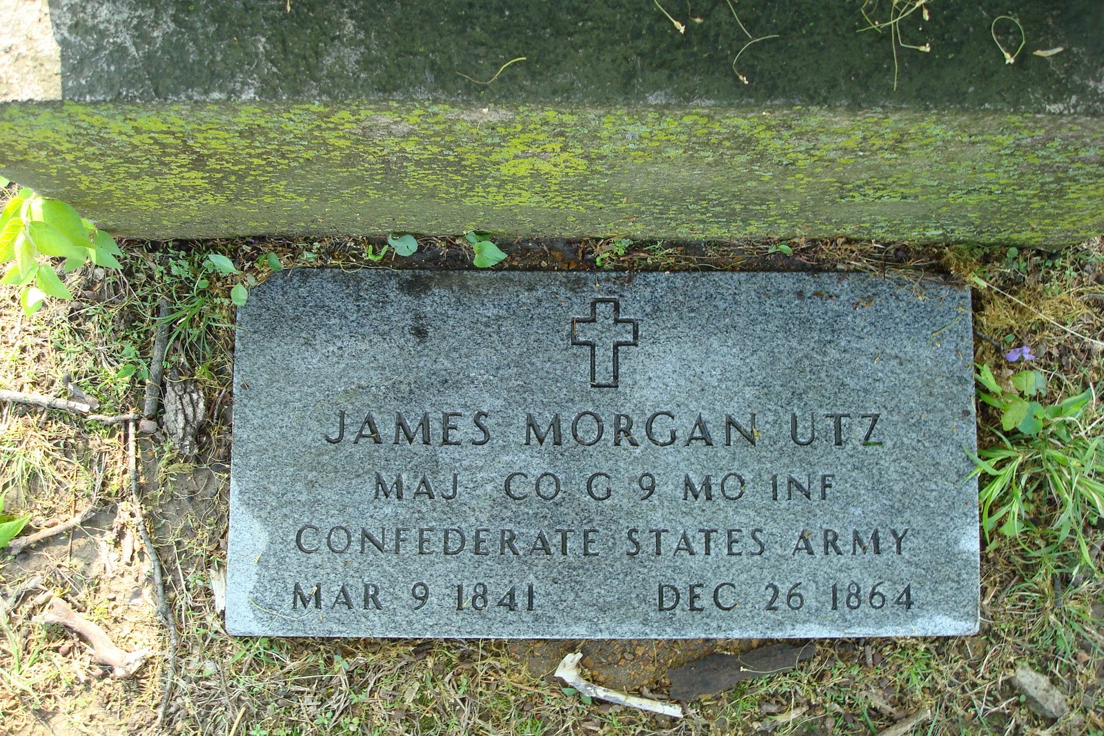
But perhaps the most interesting resident in the cemetery is Confederate soldier James Morgan Utz, who died in 1864. “He was caught as a spy here in St. Louis Lincoln St. Louis
The original Fee Fee Baptist Church Mississippi St. Louis County St. Charles Rock Road
Just behind the Meeting House is the “Preachers’ Area,” where only past preachers of the church are buried. And as one drives up to the Meeting House, to the right is “Cremation Garden
Referring to some of the older burials in the cemetery, Cox attests, “We do have some Revolutionary War burials in here, but they were moved from other unknown cemeteries.” He adds that he has “no idea” about the number of graves, because “there are a lot of unmarked graves.” He can, however, often tell if the ground has been disturbed. “If the ground’s real dry, sometimes I can tell whether it’s been disturbed or not.”
In addition to pointing out the popularity of obelisks on the property, Cox comments that there are a number of headstones with Masonic symbols, indicating the numerous Freemasons. And finally, he shares a story about why Civil War-era Union headstones tend to be flat or curved at the top, while their Confederate counterparts are often pointed like a rooftop: “So no damn Yankee can sit on them,” or so the saying goes.
Occasionally, Pattonville High School Fee Fee Cemetery Fee Free Road

Ready for the tour! Bridgeton's Payne-Gentry House.
Photos by Cindy Lay, Bridgeton


The desk of Dr. William Elbridge Payne
Countless history buffs and casual vacationers routinely travel hundreds or thousands of miles to gain some culture, enjoyment, and education by viewing some of the historic landmarks that America
Jeanne Keirle is the chairperson of the Bridgeton Historical Commission, and Cindy Lay is the secretary of the Commission. Their group is responsible for promoting the House, doing tours, and taking care of and monitoring the structure. “The [Bridgeton
The House was built in 1870, originally as a summer house that belonged to the Payne-Gentry family. The family’s tangled lineages can be traced back to John Post, who in 1821 moved his family from Vermont Chesterfield , Missouri Chesterfield Bridgeton Northwest St. Louis County
Eventually, Dr. William Elbridge Payne came to live at the House and opened his office in the basement. The irony of the name “Dr. Payne” does not elude Lay, who points out, “It is the only house on the National Register of Historic Places, or historic house in general, that had a doctor’s office attached to it. The doctor’s office was added after the House was built, but it didn’t insult the integrity of it or its historical significance.”
Likewise, the Missouri Historical Society used a photograph of the House in their literature, and it is now on their tour route, and the Missouri History Museum
The House was sold to Bridgeton Elizabeth
Elizabeth Gentry Sayad is an accomplished musician, author, pianist, and world traveler. “As a child, she came out and played in the yard until she was a teenager,” muses Keirle. “Then boys came around, and her dad wouldn’t let her out there anymore.”
Keirle adds, “When it was not popular, the ladies of the family went to college, which was unheard of at the time. It was a well-traveled family, also. They had a pioneer spirit that carried through even to today. Elizabeth
The House was dedicated in October 1966, and the whole area that it currently sits on is called Gentry Park
Keirle and Lay invite those interested to take a tour, available on the first and third Sunday of every month, or to take the popular Candlelight Tour on the first and second Saturday and Sunday of December. Private tours are also available for a very modest fee, by contacting Lay at the Bridgeton Community Center